Top 7 most beautiful roads in the world
Let's take a ride on the best roads
We at fedafone love road trips and believe that this is the best and most romantic form of vacation. You do not depend on train and bus schedules, you do not have to frantically weigh your luggage and then get with it from and to the airport, you can change your plans spontaneously or not have them at all! With the rise in fuel prices, such road trips have become less accessible, but still every traveler can afford such a vacation at least once a year.
In this article we will tell you about the most beautiful, incredibly picturesque, sometimes dangerous and 100% mesmerizing roads in the world, so that you add it to your Bucket list. Let’s go!
America → Pan American Highway

According to the Guinness Book of Records, the Pan-American Highway is the longest highway in the world - it crosses 2 continents, North and South America, from beginning to end. Starting in Alaska, it finishes in the Argentine city of Ushuaia on the island of Tierra del Fuego. The route runs through 14 countries (USA, Canada, Mexico, Guatemala, El Salvador, Honduras, Nicaragua, Costa Rica, Panama, Colombia, Ecuador, Peru, Chile and Argentina), the total length of which is 47958 km and yes, there is no mistake in numbers.
In addition, the Pan-American Highway crosses all major climate zones. The only place where the transcontinental route breaks is in the middle on the section between Panama and Colombia at a place called the Darien Gap, which must be bypassed by ferry across a body of water. This area is characterized by swamps, rugged rainforests and small but wild Indian tribes. Despite several successful attempts to overcome the Darien, in general this section is completely unsuitable for riding. The speed record for driving this longest road on the planet belongs to Tim Cahill and Harry Sowerby, who drove it from start to finish in 23 days, 22 hours and 43 minutes.
Argentina → Ruta 40

Route 40, known as Ruta 40, stretches across almost the entire territory of Argentina from north to south, parallel to the high Andean mountains. This is one of the longest roads in the world, stretching over 5,000 kilometers, which is impressive, especially considering its passage through different climatic zones. The landscape along the route is constantly changing: here you will find forests, rocks, lakes, fields, meadows, deserts, almost uninhabited pampas, asphalt and gravel areas, dust and red sand, sun and strong winds, 27 mountain passes, 18 large rivers, and 20 national parks, each of which deserves special attention and can become a place for several stop-overs.
For example, in Los Glaciares National Park, a UNESCO World Heritage Site, you can visit the Perito Moreno Glacier, which has the third largest freshwater reserve in the world. Its area is almost as big as the entire city of Buenos Aires, and it is constantly moving, shifting an average of 2 meters per day. You can enjoy the view of the glacier both from viewpoints and go for a walk along its icy surface, accompanied by a climber. Also along the route you can reach the famous “Cave of Hands” (Cueva de las Manos), where the walls are strewn with human handprints and images of hunting, some of which date back to the ninth millennium BC.
Particularly noteworthy is Argentina's second largest national park, Calchaqi Walley, where in one day you can cross mountainous deserts and enter subtropical forest, an amazing example of dramatic climate change in a small area of land. Traveling along Ruta 40 will also allow you to enjoy Martian desert landscapes and see flamingos that live on the lakes of Patagonia.
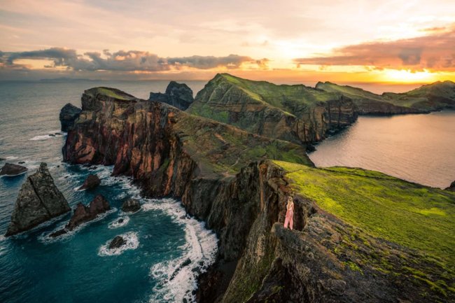
Australia → Great Ocean Road

The Great Ocean Road, 243 kilometers long, stretches along the Pacific coast of Australia. Although this road has no practical significance, it was built as a memorial to the soldiers who died in the First World War. Opened in 1932, it became the largest war memorial in the world and thirty years later was recognized as one of the most scenic roads on the planet. Running almost along the coast, the road offers breathtaking views of the endless ocean waters and quiet lagoons. Among the main attractions of this route are the mysterious “Shipwreck Coast”, where 638 ships were wrecked, as well as the “Twelve Apostles” - a group of limestone rocks, up to 45 meters high, standing in the ocean. Although there are actually only eight rocks, their name was changed to "Twelve Apostles" to attract tourists, similar to the London Arch rock, which is about 20 million years old. For a long time it was called "London Bridge" due to its resemblance to the Tower Bridge, but after the collapse of the span closest to the mainland in 1990 it became known as the "London Arch».
The unique thing about the Great Ocean Road is that the coastline is constantly changing, and what is visible today may not be visible tomorrow. A trip along this road not only allows you to enjoy beautiful scenery, relax on the beach or ride the waves, but also offers a unique Australian "safari": in Warrnambool you can see the migration of southern right whales, and in the Tower Hill Game Reserve you can meet kangaroos, emus, koalas and seabirds.
Norway → Atlantic Road

The Atlantic Road (No. 64) stretches almost along the ocean, crossing the islands through a chain of bridges and tunnels. Highway 64 is not the longest road, though it is interesting not for its mileage, but for its technical component - this amazing engineering structure includes six bridges over the entire length of only 8.5 kilometers. One of the main bridges is the Storseisundet Bridge, known as the "Bridge to Heaven". When approaching it from the mainland, the road seems to end at the highest point, causing the driver to jump into the sky. It looks especially impressive in the fall, when the storm season begins: huge waves crash against small islands, collapse on bridge supports and sometimes even cover the road, threatening cars.

The Atlantic Road is only part of the route through the fjords. Continuing towards Oslo, you will come to one of the most famous serpentines in Europe - the Trollstigen. According to legend, trolls often envelop their stairs in thick fog, which gives the serpentine a special atmosphere: gray stones, green grass and moss on the rocks are visible through the heavy mist. At the top of the mountain, visibility sometimes drops to 3-5 meters, which creates a mysterious picture with sheep emerging from the fog, black lakes and stone pyramids built by tourists or perhaps the trolls themselves. Continuing along RV63, you will come to Norway's most amazing fjord - Geiranger, where you can enjoy the view of numerous waterfalls, go fishing or just stroll around the surrounding area.
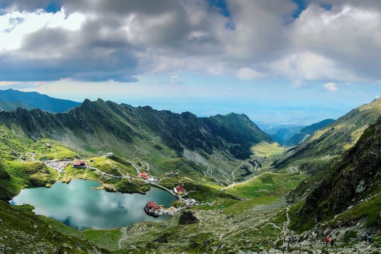
Romania → Transfagarasan
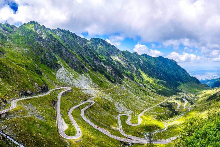
In 1970, Romanian President Nicolae Ceausescu began construction of a high-altitude highway through the Fagaras massif with the main purpose of ensuring the country's security from a possible military invasion, and not to create a tourist route. He was concerned about the events in Czechoslovakia and decided to connect the regions of Wallachia and Transylvania with a mountain road for the rapid transfer of military equipment.
Now Transfagarasan has become one of the rare examples when an object created for military purposes becomes world famous and attracts many tourists. According to numerous reviews from travelers, Transfagarasan is the most beautiful road in the world, which every self-respecting car enthusiast should drive along. The highway is 261 kilometers long, passing through picturesque valleys, fields with ears of wheat, lakes, and Romanian villages with dark stone houses. Not far from the start of the highway is the town of Sibiu with traditional Romanian architecture. Along the way you can see Orthodox and Catholic churches and mosques.
From Transylvania, travelers will find many associations with Count Dracula, reflected in the names of streets, restaurants, souvenirs and ancient castles. Separately, it is worth noting Poenari Castle, which belonged to Prince Vlad III the Impaler, and Bran Castle, which became famous thanks to Bram Stoker’s novel about Dracula.
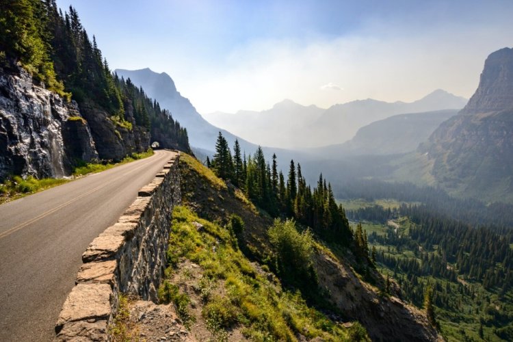
Russia → Chuysky tract

This ancient route was the first link between Russia and China for many centuries. Driving along the Chuysky tract can be compared to traveling across the whole of Russia - endless open spaces and no one for kilometers ahead. You can start your journey in the city of Biysk with its birch groves and villages, one of which was the birthplace of the writer Vasily Shukshin; after hundreds of kilometers you find yourself in Gorno-Altaisk, where it seems that you are in the era of the development of Siberia: the stormy waters of the Katun River, rocky gorges and green valleys of mountain taiga. Turning left, you will reach Lake Teletskoye, and to the right - the foot of Belukha, where Nicholas Roerich looked for Shambhala on his way to the Himalayas. Continuing straight ahead, you will see the Kurai steppe at the foot of the North Chuya ridge. This route is not suitable for a short holiday as each turn offers its own exciting journey.
The Chuisky tract, formerly known as the Mungalsky tract, was mentioned in Chinese sources thousands of years ago. From then until the beginning of the 20th century, it was simply a mountain path used by merchants and pilgrims. The wheel road from Ongudai to Kosh-Agach was built only in 1903. Today, the Chuysky tract is one of the few roads in the world that has its own museum in the building of the Biysk Museum of Local Lore, where archival documents, photographs, road models, paintings and dioramas are presented.
Kyrgyzstan and Tajikistan → Pamir Highway
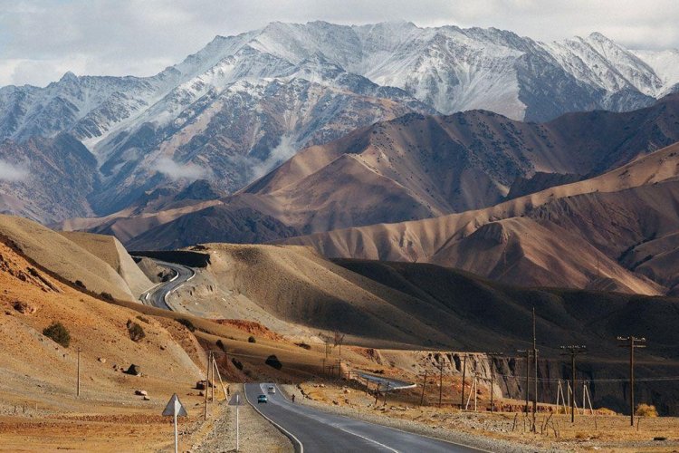
Places marked as “the very best” always attract travelers: the westernmost point of Europe, the northernmost point of Russia, the highest mountain, the deepest depression. One of such places is the Pamir Highway - the highest mountain road in the territory of the former USSR. This almost entirely dirt road runs along the spurs of the Pamir Mountains and crosses the three main mountain passes of the Pamirs: Taldyk (3615 meters), Kyzyl-Art (4280 meters) and the closest point to the “Roof of the World” - Akbaital Pass (4655 meters). The eastern part of the tract, from the Kyrgyz city of Osh to the Tajik Khorog, was built in 1931-1934, when the USSR was actively developing the territory of the mountain Pamirs. This section passes through green foothills where horses graze, lonely yurts and dung-smeared huts, and past the Pamir National Park, with Lenin Peak (7,134 meters) in the background.
One of the most exciting stops on the route is Lake Karakul, the largest in Tajikistan, located at an altitude of 3914 meters above sea level. From here begins a steep climb to the spurs of the great Pamirs. Rocks, gorges, tunnels, dirt roads, dust, lack of vegetation, rare villages and flocks of sheep - this almost Martian landscape extends all the way down to the valley on the Tajik side. Your travel companions will be trucks, donkeys and jeeps, overloaded inside and out. Turning off the road, you can visit several more interesting places: the villages of local residents, the “Farewell to Youth” pass, the fortress of fire worshipers Yamchun, the Bibi Fatima hot springs and much more.
When traveling by car, unfortunately, you never know what awaits you around the corner. You may have a flat tire, you may need the help of a tow truck, and of course, you simply need a navigator, because relying only on offline maps is quite presumptuous. Don't forget to buy fedafone eSIM and activate the network before your travel - so you could worry only about your phone's battery, not your credit!